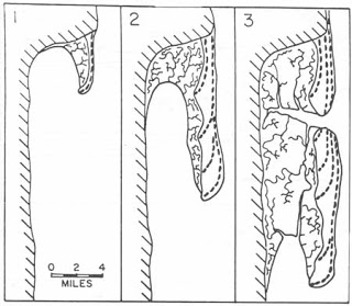
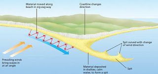
Coastal geomorphology is defined as “the study of the morphological development and evolution of the coast as it acts under the influence of winds, waves, currents, and sea-level changes” (Leatherman). The Sandy Hook Herbarium Geologist also intended to determine the relationship between different types and properties of sediment and how this can influence the types of plants that can grow in certain locations. Sandy Hook is a sand spit that divided Sandy Hook Bay from the Atlantic Ocean. Sand spits are formed when Longshore Currents carry sediment along the coast and build up on a beach, where currents are blocked and can no longer move the sand. Over time smaller sediment builds up on top of that, eventually causing this sandbar-like formation to rise out of the water and form land. Sediment will continue being deposited by longshore currents and accumulating, extending the spit even more. Occasionally the currents will change direction over time, due to wind reversing directions, causing sand to build up going in the opposite direction, a process which gave Sandy Hook its namesake “hook” shape. Barrier spits will eventually stop growing because they reach a point where wind and water erode the land faster than new sediment can be deposited. It is a common feature of sand spits for marshes to form on the protected side, mostly in salty bodies of water. Sand spits often change shape over time due to many of these factors, much in the same way that is visible on Sandy Hook.
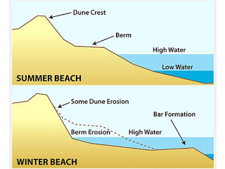
The sediment on Sandy Hook has been being deposited for thousands of years, changing through the Ice Age to today. In the past few centuries alone, Sandy Hook has changed shape drastically. New sediment is constantly being deposited by longshore currents. New sediment is deposited in different areas from parts of the spit that were formed hundreds of years ago. I intend to take samples from many different areas on Sandy Hook and analyze them to find their properties. From this data, I will determine the difference between the types of sediment in different locations and be able to map the sediment types and geology of Sandy Hook. After doing this I can also look at what types of plants can grow in a certain area, and relate this to the properties of the sediment in that location, to find what certain species are best suited for. Coastal geomorphology has a huge influence on sediment in certain areas. Seasonal changes in beach landscapes are vital to understand. For research and analytical purposes, it is important to know that the profile of the beach as well as the type of sediment changes from winter to summer. In the winter/spring time period, beaches are shorter and steeper due to bigger and more forceful waves. These stronger waves also carry away smaller grains of sediment, which is very important for me to consider when classifying some of my research. In the summer/ fall season, the smaller waves bring more sediment to shore, widening the beach with smaller sediment particles and creating a profile that is longer and much less steep. Understanding these concepts are very important for the research the geologist must conduct and understand how coastal geomorphology is influenced not only by longshore currents, but also seasonal movement.
2,671 total views, 1 views today